New precious acquisitions supported by Dr. Ko Pui-shuen’s donation:-
1. The Black Map (Da Qing Wan Nian Yi Tong Dili Quan Tu)
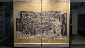
An extraordinarily rare cartographic document that is based on research originally presented to the Qianlong emperor by Huang Qianren 黃千人 (fl. 1760 – 1770) in 1767. The title of the map is as much a political programme of the Qing as it is a geographical record. It shows China at the height of the Qing empire, celebrating the unified status of all of Chinese borders.
The map was designed to act not only as a grand political statement of the Kingdom’s place in the world, but also as an administrative tool. Its surface is dotted with provincial capitals (sheng 省), a square with a small rectangle on top; prefectures (fu 府), a square; independent district magistrates (zhilizhou直隸州), a square with a triangle on top; departments (zhou州), a vertical rectangle; sub-prefectures (ting廳), a diamond; districts (xian縣), a circle; frontier passes (guan關), a small building; local headmen or western tribute states (tusi土司), a triangle; with the name appearing within each pictogram. The borders of each province are denoted by dotted lines.
2. Yu Ji Tu
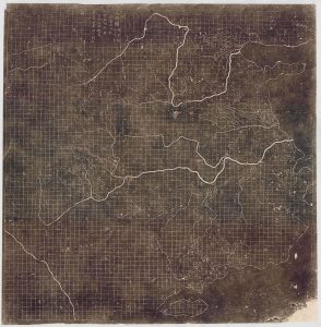
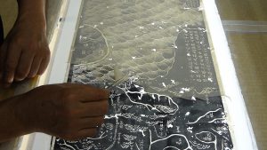
Our most recent acquisition, and the earliest map in our collection– this is a 19th century Chinese rubbing of the Southern Song Dynasty 1137 Yu Ji Tu 禹跡圖, or Map of the Tracks of Yu Gong, from the original stone carving in Xian. It is a milestone in the history of science and the most accurate map produced anywhere at that time.
It shows which level of geographical knowledge was available in China before the contact with the West. The Yu Ji Tu is one of the earliest and most important Chinese maps ever produced. Issued at a time when European cartographers were focused on religious symbolism more than geographic realism, this Chinese map exhibits a cartographic accuracy and meticulousness comparable to 20th century mapmaking. This is the earliest map to employ a rectilinear grid system.
Read more on georeferencing the Yu Ji Tu – “Yu laid out the lands”: georeferencing the Chinese Yujitu [Map of the Tracks of Yu] of 1136 (with Alexander Akin), Cartography and Geographic Information Science Journal, 2012.
Digital reprint available from Prof. David Mumford’s website
3. Dili Tu
 The Dili Tu 墬理圖 [Geographic Map of China] was engraved in 1247 on a stone stele now kept in the Museum of Engraved Stone Tablets at the Suzhou Confucian Temple. This is a rubbing of the original stone made in the early 20th century and mounted on a scroll.
In this map, China is laid out on the top two-thirds of the rubbing, with hundreds of settlements shown in oval and rectangle cartouches. Mountains, hills, and forests are elegantly added in among the characters, with China’s many rivers flowing throughout. The bottom third of the rubbing is filled with notes describing not only the geography, but also the history of China. The thrust of the narrative discusses the perennial fragmentation and reunification of the empire and the need for the Southern Song dynasty to fight to reconquer the North.
See transcription and translation
4.Rughesi map of East Asia
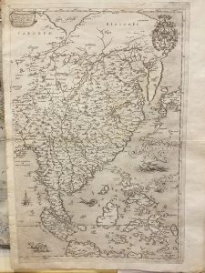
[Map of East and Southeast Asia]
This map is the eastern part of a 1597 map of Asia by the Italian cartographer Fausto Rughesi. As well as being extremely rare (only 3 other copies are known) it contains significant new cartographic information for China, Korea and Japan, probably derived from Jesuit sources, recently transmitted to Rome.
It is only the second printed map to show Korea as a peninsula rather than an island and it has the most detailed rendering of the Middle Kingdom to appear on any known printed map to date.