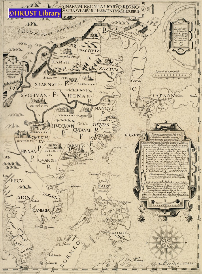
1. Sinarum Regni Alioruq. Regno/Ru Et Insularu Illi Adiacentium Descriptio, ca. 1590
47x35cm
An extremely rare engraved map, centered on China, but showing the Malay Peninsula, Northern Borneo, the Philippines, the Korean Peninsula, and Japan. Interesting features include the Great Wall, an accurate depiction of the course of the Yellow River, delineations of the 15 Provinces, and an inserted table showing different administrative and regional divisions in each Province. Anonymous (possibly after Matteo Ricci & Michele Ruggieri). |

2. Mont van der Rivier Chincheo in China, 1646
16x20cm
An engraved map of the Bay of Amoy (廈門) in Fujien Province. It is one of the earliest detailed Western charts to depict the coast of China.
By Isaac Commelin from his Begin ende voortgangh van de Vereenighde Nederlantsche Geoctroyeerde Oost-Indische Compagnie. Accompanies Zeyger van Rechteren’s description of his voyage to East Asia and Southeast Asia in 1629 as a Dutch East India Company doctor. |
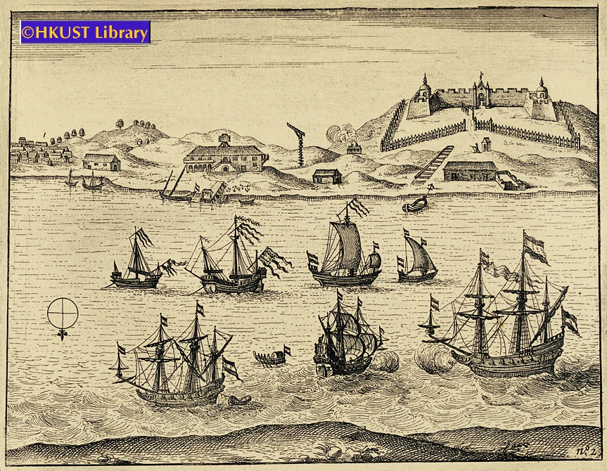
3. View of Fort Zeelandia, Taiwan, 1646
15x20cm
An engraving showing the settlement of Fort Zeelandia (安平古堡), ca.1631. It shows the four bastions of the fort (each surmounted by a tower), a wooden outer stockade (stone outer ramparts were not completed until 1633), and the warehouses and buildings of the adjacent settlement of Provintia.
By Isaac Commelin from his Begin ende voortgangh van de Vereenighde Nederlantsche Geoctroyeerde Oost-Indische Compagnie. Accompanies Zeyger van Rechteren’s description of his voyage to East Asia and Southeast Asia in 1629 as a Dutch East India Company doctor. |

4. Maccauw, 1646
15x20cm
This engraving is the first available Dutch view of Macau. It shows the Cathedral Church of S. Paulo with its prominent steps, other monastery churches and fortifications, and the Temple of Ama (媽閣廟), still a popular tourist sight today.
By Isaac Commelin from his Begin ende voortgangh van de Vereenighde Nederlantsche Geoctroyeerde Oost-Indische Compagnie. Accompanies Zeyger van Rechteren’s description of his voyage to East Asia and Southeast Asia in 1629 as a Dutch East India Company doctor. |

5. Vue de l’Ile Tiger, Située sur le Bocca Tigris et Nommée Tailoc Tow par les Chinois, 1794
17x24cm
This engraving depicts a view of Tiger Island just to the North of the Bocca Tigris (虎門) with its distinctive cleft hillside. It also shows a Chinese junk and sampans.
View of the Pearl River based on observations made by John Meares during his first voyage to Hawaii and Guangzhou. |

6. Vue de l’Entrée du Bocca Tigris, Conduisant à Canton, 1794
17x24cm
An engraving showing the Bocca Tigris (虎門) with the Chinese forts at Chuenpee (穿鼻) and Anunghoy (威遠島) on either side of the Estuary (later sites of battle in the Opium War). It also includes a fine drawing of a Chinese junk and sketches of sampans.
View of the Pearl River based on observations made by John Meares during his first voyage to Hawaii and Guangzhou. |

7. Pic de Lantao, 1794
17x23cm
One of the first detailed Western depictions of Lantau Island (大嶼山) from observations made by a crewman ca. 1788.
View of the Pearl River based on observations made by John Meares during his first voyage to Hawaii and Guangzhou. |

8. De Stadt Quemuy, ca. 1729
25x35cm
This detailed engraving shows the harbor of Quemoy (金門) with junks and sampans in the water, and city wall and buildings of the city on the top of the hill. Quemoy was an important trading post for the English and Dutch at the time.
Originally published in 1670 to accompany the account of Johannes Nieuhof’s Dutch Embassy to China in 1655. These are later re-engravings by Pieter van der Aa, published ca. 1729. |

9. De Stadt Aymuy, ca. 1729
25x35cm
This engraving shows the harbor of Amoy (廈門) with junks and sampans in the water, houses along the coast, and rugged mountains in the background. Amoy was an important trading post for the English and Dutch at the time.
Originally published in 1670 to accompany the account of Johannes Nieuhof’s Dutch Embassy to China in 1655. These are later re-engravings by Pieter van der Aa, published ca. 1729. |

10. La Ville et le Château de Zélandia dans l’Ile de Tayovan, en Chine, ca. 1729
29x35cm
This engraving shows the Dutch fort and settlement of Zeelandia on the west coast of Taiwan. On the right is a curved sandy promontory with the castle and battlements; on the left is the town, while junks and sampans fill the water around the settlement. It was re-engraved by van der Aa in 1729, over 60 years after the Dutch were expelled by the Ming Loyalist, Koxinga (國姓爺鄭成功), and over 40 years after it was re-taken by the Qing.
Originally published in 1670 to accompany the account of Johannes Nieuhof’s Dutch Embassy to China in 1655. These are later re-engravings by Pieter van der Aa, published ca. 1729. |

11. Platte Grond vande Stadt Macao, 1724-1726
27x36cm
An engraved perspective map of Macau viewed from Lappa Island (對面山) but on a slightly larger scale extending to the Barrier Gate at the north of the promontory. Taken from Francois Valentyn’s Oud en Nieuw Oost Indien, a 5 volume encyclopedia on the Dutch East India Company’s empire, published 1724-1726. |
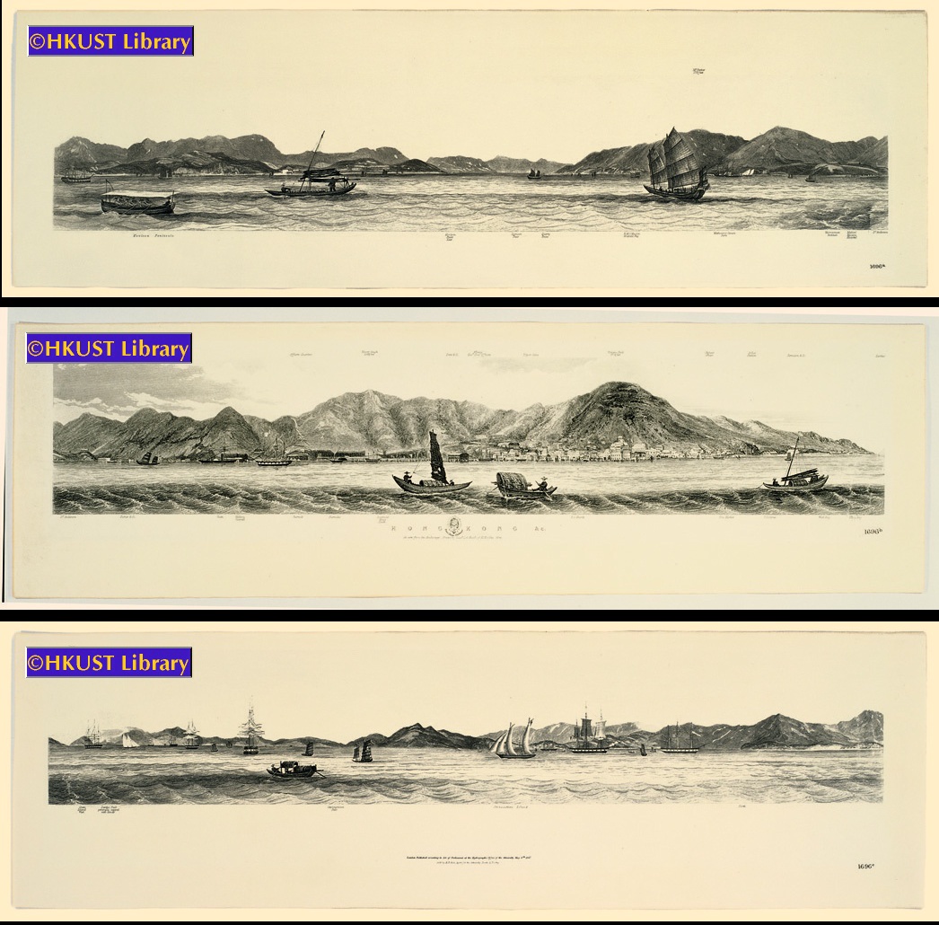
12. Hong Kong Etc. as Seen from the Anchorage, 1846
12x69cm x 3
These three views can be connected to reflect one long panoramic view of the coast of Hong Kong, from the Kowloon peninsula to Hong Kong Island, then to Lantau Island (大嶼山) and Stonecutters Island (昂船洲), by Lieut. L. G. Heath of H.M.S. Iris. |